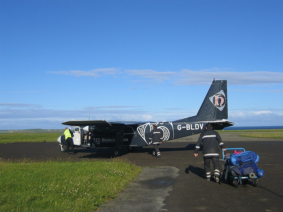
Flight History
On 8 March 2000, a BN2B-26 Islander (registration G-BLDV) operated a public transport air ambulance flight from Glasgow to Stornaway. The aircraft carried one pilot and two passengers; no injuries occurred and no damage was sustained. The pilot held an ATPL with 7,241 total flying hours, including 485 on type. The flight took off from Runway 23 at Glasgow at 0850 UTC. Climbing through 4,000 feet, the aircraft came under a Radar Advisory Service from Scottish Area Control Centre (ScACC) at Prestwick, initially cleared to FL 85. The commander requested FL 95 but was advised it was an incorrect quadrantal level and accepted FL 105. By 0911 UTC, he reported being unable to reach FL 105, possibly due to mountain wave activity, and descended back to FL 85. At 0935, he requested an operating band from FL 65 to FL 85 because of more pronounced mountain wave activity. The aircraft entered icing conditions and used both propeller and airframe de-icing systems, which operated satisfactorily.
At 1012 UTC, in IMC at FL 65 with an indicated airspeed of 110 kt, the pilot noticed a sudden buildup of ice on the wheels, struts, and tyres. Unable to maintain altitude, he requested radar vectors to a clear area. ScACC suggested turning west towards the coast, estimated 8 miles away. The pilot declared an emergency and set the transponder to 7700. He reduced speed to 70 kt and descended at that speed with engines at full power. About 3 nm from the coast at 4,200 feet, the aircraft entered clear air and the ice melted rapidly. The pilot then continued to Stornaway, climbing to FL 75, and landed at 1126 UTC.
Aircraft De-icing Systems
The aircraft was cleared for flight into known or forecast icing conditions no more severe than light. It was equipped with serviceable de-icing systems including pitot head and stall warning vane heaters, an aircraft heater and windscreen demisting system, electrical propeller de-icing, an airframe de-icing system, and an electrically heated glass panel in the pilot's windscreen. The pilot also carried an electric torch to illuminate the wing leading edges. The airframe de-icing system used pneumatic inflatable boots on the leading edges of the wings and tail, controlled electrically for manual or automatic cycling. The system was to be used intermittently; continuous operation risked ice forming over the inflated boot profile, rendering the system ineffective.
Meteorology
The synoptic situation at 0900 UTC showed a complex low pressure area north of the Shetland Islands with a slow-moving warm front from Campbeltown to York. A strong unstable westerly airstream covered the area. The forecast available to the pilot indicated various cloud layers and visibility conditions. Warnings included moderate icing and moderate turbulence in cloud, isolated severe turbulence below 7,000 feet, and severe icing in nimbostratus clouds. A mountain wave warning included maximum vertical speeds of 550 fpm near 9,000 feet. Destination weather was forecast as good with strong westerly winds, visibility greater than 10 km, and few clouds at 1,500 feet. An aftercast confirmed the forecast conditions, depicting wind profiles indicative of standing waves. The uplifted air associated with these waves could increase water density and icing risk, particularly in orographic motions.
Operating Instructions
The operator had issued a Notice to Aircrew providing guidance for flight in forecast icing conditions, stating that if significant airframe icing was suspected, pilots should not plan to route over the highest ground but go around it. The selected airway (A1 D) passed over the Grampian Mountains and close to Ben Nevis (4,410 feet). An alternative route via airway N 573 D to Tiree, along the western coast of Scotland, went over lower terrain and would have been less affected by standing wave activity and increased icing severity.