Flight Details
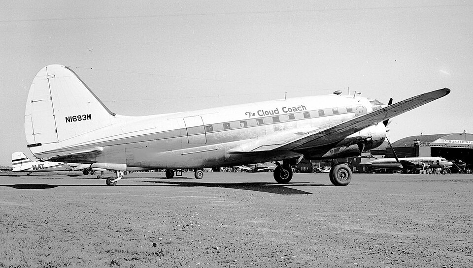
American Air Transport, Inc., an irregular air carrier, operated a ferry flight from Columbia, South Carolina to Seattle, Washington on April 22, 1953. The purpose was to later conduct a Civil Air Movement of military personnel. The aircraft, registration N1693M, was flown by Captain John W. Schroeder and First Officer James P. Gilbert from Columbia to Cheyenne, Wyoming without incident.
At Cheyenne, a second crew—Captain Maurice A. Booska, the company's Chief Pilot, and First Officer Donald F. Dwelley—relieved the first crew, who continued as passengers. The aircraft was serviced with 1,200 gallons of 100-octane gasoline.
Sequence of Events
Captain Booska received a weather briefing and filed a VFR flight plan to Boise, Idaho via Airways Green 3 and Red 1. Departure from Cheyenne was at 2043 MST after a delay to repair the left navigation light. The flight proceeded uneventfully, with position reports over Rawlins and Rock Springs, Wyoming; Malad City and Burley, Idaho; and three minutes east of Boise at 2252. Altitude was reported as 12,000 feet except at Rock Springs and Malad City.
Boise radio provided the Boeing Field-Seattle forecast and en route weather, after which the pilot filed an IFR flight plan. At 2254, the following clearance was transmitted: "ATC CLEARS N1693M TO THE SEATTLE RANGE VIA RED 1, BLUE 32 BLUE 12, GREEN 2. MAINTAIN 12,000 FEET." The pilot acknowledged.
Position reports continued: over Baker, Oregon at 2331 at 12,000 feet; over Pendleton, Oregon at 2353 at 12,000 feet. Near Yakima, the flight was cleared to descend to 10,000 feet, and upon reporting over Yakima at 0026, it was cleared to 8,000 feet. At 0037, the flight reported over Ellensburg 2 at 0034 at 8,000 feet IFR.
Ellensburg radio transmitted the Boeing Field 2330 weather at 0040; the pilot acknowledged and said he would contact Seattle Air Route Traffic Control Center when over Easton. At 0047, the pilot reported over Easton at 8,000 feet inbound to Boeing Field. Seattle Center issued the following clearance: "NECTAR ONE SIX NINE THREE METRO YOU ARE CLEARED TO CROSS HOBART AT 8,000 SEATTLE AT OR ABOVE 4,000 MAINTAIN 4,000 NO DELAY EXPECTED CONTACT SEATTLE APPROACH CONTROL OVER HOBART FOR FURTHER CLEARANCE OVER."
The controller heard the pilot read back: "ROGER, CLEARED TO - - - -(distinct pause) CROSS THERE FOUR THOUSAND OR ABOVE THE RANGE STATION, AH, FOUR THOUSAND, REPORT HOBART TO YOU." The controller corrected the reporting point error: "NEGATIVE REPORT HOBART TO SEATTLE APPROACH CONTROL." The pilot replied, "HOBART TO SEATTLE APPROACH CONTROL ROGER."
No further transmissions were received. When the flight failed to report over Hobart and became overdue, controllers attempted contact without success. Search and rescue activities were initiated the next day, and the two survivors were rescued.
Investigation and Findings
The official investigation determined that the pilot misunderstood the clearance, failed to check en route altitude against available charts, and descended below the prescribed minimum en route altitude. The controller did not detect the first of two errors in the pilot's read-back—the incorrect crossing altitude for Hobart—which was a contributing factor. The aircraft descended below 8,000 feet and crashed near the crest of a mountain at 4,000 feet MSL. Both pilots likely experienced impaired efficiency due to oxygen want and fatigue. No aircraft malfunction or failure was found.
Probable Cause
The Board determined that the probable cause of the accident was the pilot's misunderstanding of the clearance, failure to check en route altitude against available charts, and descent below prescribed minimum en route altitude. The controller's failure to detect the first error was a contributing factor.