Published 2026-07-04 · Data updated 2026-07-05
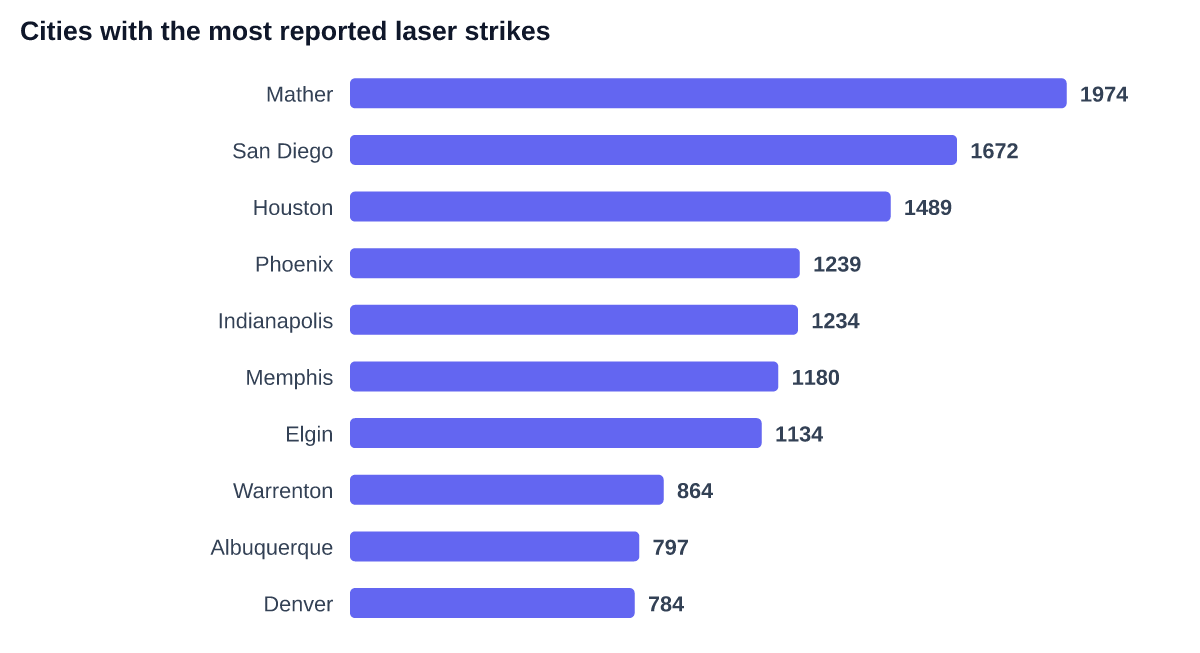
Since 2021 the FAA has logged 54,722 reports of lasers pointed at aircraft. Sort them by city and the list starts sanely — San Diego, Houston, Phoenix — except for the line at the very top: Mather, California, an unincorporated Sacramento suburb of a few thousand people, with 1,974 reports.
Mather is not a hotbed of laser crime. Mather is where Northern California TRACON (NCT) sits — the radar facility that works arrivals and departures for the entire Bay Area and Sacramento Valley. When a crew reports a laser to NorCal Approach, the FAA record carries the reporting facility's location. Thousands of strikes that happened over Oakland, San Jose or Sacramento are filed, on paper, in Mather.
| Facility | State | Reports |
|---|---|---|
| NCT | California | 1,974 |
| SCT | California | 1,443 |
| ZME | Tennessee | 1,421 |
| ZTL | Georgia | 1,139 |
| C90 | Illinois | 1,134 |
| ZSE | Washington | 1,035 |
| P50 | Arizona | 1,014 |
| ZID | Indiana | 971 |
The lesson generalizes: government incident datasets encode their own reporting plumbing. Any per-city ranking of FAA laser data is really a mixed ranking of geography and bureaucracy — and the number one "city" is the clearest tell. Filter the facility codes out and the real geography emerges: Southern California, Texas and Arizona metros lead, roughly tracking population and clear-sky nights.
Methodology
Source: FAA Reported Laser Incidents (public domain), 54,722 reports, 2021–present, as normalized in the FlightFinder safety corpus. City and facility attributions are reproduced as filed by the FAA; we identify ATC facilities by their three-letter facility codes (NCT, SCT, ZME, ZTL and similar are TRACONs and en-route centers, not airports). Numbers recomputed nightly from the live database.
Cite this
FlightFinder analysis of FAA Reported Laser Incidents, 2026. Underlying data: FlightFinder Data API.
Sources: FAA Reported Laser Incidents (public domain) · FlightFinder laser-strikes vertical: /safety/laser-strikes
Query this data yourself — Data API from $49/mo · Litigation research dossiers